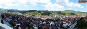
The Rožaj area geographically stretches between 42° and 45' and 42° and 59' north latitude and 17° and 41' and 18° and 0' east longitude. It is located in the northern part of Montenegro, that is, on the triple border of Serbia, Montenegro and Kosovo. The municipality of Rožaje is located in the northeastern part of Montenegro. It is covered by the Montenegrin Prokletije, and in its immediate neighborhood are southwestern Serbia and Kosovo, so this region represents a triple border.
The Rožaj area has a developed relief and a high average altitude, and as such it can be classified as a high mountain area with certain specificities, covering an area of 432 km2. The city itself is located at 1006 m above sea level. It is surrounded by high mountains on the southeast side, towards Kosovo I'm saving (2272), Rusoli (2381), Groove (2352), Sijenova (1954), Mark (2043) i View (2154). Jugozapadna granica, koja odvaja rožajsko područje od Rugova, goes with the top Come on, whose highest peak is 2403 meters high, and Dermandola (2119).
The border towards the Beran basin is formed by mountains Smiljevica (1963), Hidden (1688), i Katzuber (1573). Sa sjeverozapadne strane, prema Gornjem Bihoru i Pešteri, Rožaje gleda na niz relativno nižih planinskih vrhova: Turjak (1469), Vlachs (1543), Musa's pit (1655), Gradina ( 1754), Cruiser(1756). Sjeveroistočnu granicu čine Vranjača (1545), Friday (1432), Mark's baptism (1355), Brezovica (1300),Reef (1148), Vučan forests (1143) i Fat hill (1086).